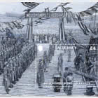
1st Edition Alderney and Burhou Map

| Set |

| Miniature Sheet |

| Sheetlets |

| First Day Cover |

| First Day Cover MS |

| Presentation Pack |

| Presentation Pack |
Gifted architect Addison Roger Warren, known as Roger among family and friends, arrived on Alderney in the Bailiwick of Guernsey in 1956 with his wife and two young daughters. His talent and foresight would see him help to influence the shape and character of the tiny island that would be his home for the next 41 years.
On 6th June, 1944, when thousands of Allied troops landed on the beaches of Normandy, just 10 miles away from Alderney, in the D-Day Landings, Rogers's maps provided invaluable intelligence. Roger, who at the time was based at Government Communication Headquarters -GCHQ -in Cheltenham, was one of the few people who knew of the impending landings, Sworn to secrecy, he had to remain at the base during the campaign.
Following the war, before Roger and his family moved to Alderney, he painstakingly compiled and personalised his map of Alderney and Burhou, which took him some 3,000 hours to complete, such was his interest and patience.
Alderney - Recommended stamp issues


WOPA+ recommended stamp issues

| Avatar - Fire and Ash |
| Issued: 03.12.2025 |
| ›New Zealand |
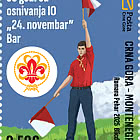
| 50th Anniversary of the Founding of the 24th November Bar Scout |
| Issued: 24.11.2025 |
| ›Montenegro |
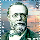
| Krisjanis Valdemars |
| Issued: 02.12.2025 |
| ›Latvia |

| Sign Language - Good |
| Issued: 02.12.2025 |
| ›Bosnia and Herzegovina - Republic of Srpska |

| In Memory of the Fallen and Murdered on October 7, 2023 |
| Issued: 08.10.2025 |
| ›Israel |

| Annual Collection Folder (New York) |
| Issued: 05.12.2025 |
| ›United Nations |

| Year Set |
| Issued: 24.11.2025 |
| ›Isle of Man |
| Shipping in the 17th and 18th Centuries - Peat Shipping |
| Issued: 05.12.2025 |
| ›Netherlands |