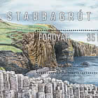
Approximately midway on the east side of the island of Sandoy, one of the Faroe Islands’ most striking landmarks faces the tempestuous Atlantic Ocean.
This is the Skálhøvdi promontory, which separates the two villages, Skálavík to the north and Húsavík to the south. In the topographical sense, a ”promontory” is the term for a headland with its highest point jutting out into the sea. Ravages of time, erosion and repeated landslides have gradually eroded the seaside rock resulting in an indentation at the end, a so-called ”barmur” with vertical rock sides - thereby creating the distinctive headland that characterizes Skálhøvdi’s features.
In his book ”Søgur og søgubrot” (Stories and Fragments), Jóannes Dalsgaard tells us that Skálhøvdi was the last place on Sandoy where the old Faroese sheep breed existed before it was exterminated. Female sheep on Skálhøvdi used to have small upright horns – and the reason, according to the old shepherd, Pætur í Búð, was the fact that they were in part descendants of the old breed. Legend has it that a long time ago, ”big birds”, ie. guillemots, teals and razorbills bred in Skálhøvdi’s rock wall. But after a large landslide, the entire bird mountain crashed down on the Torvunøs indentation and the birds subsequently disappeared from the mountain.
The village of Skálavík, reportedly, had an original sandy beach just like Húsavík on the other side of Skálhøvdi. After a hurricane, possibly the infamous Candlemas hurricane in 1602, the sand disappeared and instead the beach became covered with pebbles. Someone puts this phenomenon in connection with the aforementioned landslide in Skálhøvdi, but that is improbable.
The pebbles have probably been there all along, just buried under the sand. And it probably takes some more time along with other conditions to shape the beautiful pebbles that make up the beach of Skálavík and Skálhøvdi. They were probably deposited back in the ice age, which incidentally shaped both Skálhøvdi and the valleys where Skálavík and Húsavík are located.
Even though the big birds disappeared from the mountain in Skálhøvdi, men from Skálavík could still hunt the smaller puffin, south of Borðtangi. A hole had been made through the seaweed, so that at low tide you could walk barefoot from the beach under the indentation, over to a place on the south side, wherefrom puffins were caught with ”fleygingarstong” - a racket-like rod with a net at the end.
In the sea just off the promontory, there is also a skerry, popularly called Flidnasker, because it was populated with common limpet (patella vulgata), ”fliða” in Faroese. There they used to pick up the limpets that were used for bait in coastal fishing.
Skálhøvdi is the landmark of the village of Skálavík. An impressive phenomenon of nature and geology, whose dimensions are best viewed from a boat at sea. Such a visit is most definitely recommended if you are lucky enough to be in the area.
Anker Eli Petersen