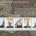
On 25 March, Åland Post issues a stamp in the 2021 Sepac series on the theme historical maps issued by the small European postal administrations. The Åland contribution shows a nautical chart from 1747 of Rödhamn, a group of islets located off Mariehamn, close to a major waterway. For centuries, Rödhamn has served as a sheltered harbour for seafarers.
Located by the Åland Sea approx.10 nautical miles off Mariehamn, Rödhamn
is familiar to all seafarers who have used the waterways between Finland and Sweden. Protected from all types of weather and with a muddy sea bottom for good anchoring, it has, for centuries, been a safe harbour for galleasses, sloops, yachts, Swedish warships, and Russian galleys before crossing the open sea. Today, pleasure crafts jostle in the harbour.
Rödhamn is the name of the harbour but, today, de nes the entire group of is- lets consisting of Långö, Ljungskär, Gloskär and Rödö. On Rödö, we nd remains of a medieval seafarer’s chapel. On Gloskär stood a sailor’s inn from the 1750s until the early 1900s, and one of the rst radio beacons in Finland was active on Långö 1937–1970. A pilot station located on the highest point of Långö bears witness of pilots stationed on the islet until 1928. The maritime traf c could be fully controlled from Rödhamn.
The nautical chart on the stamp was drawn up in 1747 by Jonas Hahn (1703- 1759), a Swedish pilot of cer who carried out maritime measurements around Åland and southern Finland. Measurements were then made rst and foremost to chart the archipelago for navy requirements, establish fairways and locate good harbours for warships.